Thursday, 30 October 2008
Precedent Studies - The Gates, NYC
Tuesday, 28 October 2008
Saturday, 25 October 2008
Tending the Tributaries 1 - Bus Station
The top image here shows the existing main routes from the bus station to Briaggte. The second image is an initial exploration of how these main flows could be re-directed and redefined to create new tributaries which enhance the experience of the journey. This is very crude, but I'll be working it up from this point into a more substantial diagram.
Friday, 24 October 2008
Briggate's historical grain
These images represent how the building grain on what is now the pedestrian section of Briggate has developed since the 18th century. These images were produced using the historical maps. Not considering individual plots, the massing of the buildings seems to have evolved in a circle over the past few hundred years; although I think this contradicts with the burgage plots history we discussed earlier in the week (more on that in response to Rick's post yesterday). I would suggest that the plots were initially built directly next to each other but the need for access to the rear created the alleyways and yards apparent in 1815 and 1850 altered this. By the 20th century some of these yards were filled in and by 2008 few remain. The 1850 and 2008 images provide the clearest comparison I feel. Anyway, something to develop.
Thursday, 23 October 2008
_ light node development
_redefinition group discussion 23rd Oct . . .
Tutorial Meeting 21st Oct . . .
- Courtyard and Alleways of Leeds by Stuart Fell
- Navigation of Cities by Kevin Lynch
- Lamberts Courtyard by Stuart Fell.
- The Image of the City by Kevin Lynch- grain, landmarks and nodes, how they work in cities.
Monday, 20 October 2008
Sunday, 19 October 2008
Connecting the City, Part 2.
Following the comments, here's another version of the above image with the lower diagram changed so that only the new/altered connections and nodes are in colour and the arrows have been removed.
Saturday, 18 October 2008
two steps backwards . .
Thursday, 16 October 2008
_ 16th Oct Group Discussion
- Linking the nodes,: highlighting a series of important spaces and areas for a series of events and possibilites eg. green spaces, urban tree houses, as well as including existing ones such as city square.
- Horizontal and vertical elements in a molecular type structure.
- Briggate as a pier: bringing people above the ground level and sea of consumerism.
- Gives the opportunity to reduce decaying spaces to improve the physical and visual links. These will form ket new nodes in the city.
- Creating a molecular structure throughout the city.
- Briggate as a core of ocean events.
- DEFINITION . . . 'A decaying sea of consumerism'
- REDEFINITION . . . 'Core of a vibrant ocean of events and possibilites'
urban treehouse
Wednesday, 15 October 2008
Redefining Briggate
fighting back the decay
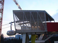
Portland Aerial Tramway
The Portland Aerial Tram is an aerial tramway in
The tram cost $57 million to build—a nearly fourfold increase over initial cost estimates, which was one of several sources of controversy concerning the project. A round-trip tram ticket costs $4; the tram is free for OHSU employees, patients, students, and visitors.
The tram consists of two stations and a single intermediate tower. Two tram cars operate on parallel track ropes and are pulled in unison by a haul rope which is driven by an engine at the lower terminal; when one car is at the upper terminal, the other is at the lower terminal, and vice versa. The lower station is located beside an OHSU facility in the South Waterfront neighbourhood, adjacent to a stop on the Portland Streetcar line, which connects the South Waterfront neighbourhood with downtown
The tram route crosses over Interstate 5 as well as major thoroughfares such as Barbur Boulevard, Oregon Route 10 (Naito Parkway), and Oregon Route 43 (Macadam Avenue). The intermediate tower is located east of Interstate 5 close to the South Waterfront station. As a result of this configuration, much of the journey is significantly elevated above the ground, making the tram easily visible for some distance, and providing tram riders with good views of the eastern metropolitan area and the Cascade Mountains of Oregon and
. . . . ed's thought for the day
I think that we only need to identify the places of decay, its a tricky one because if we remove+add stuff all we are doing is creating a proposal, is it worth looking to the streets that connection to Briggate for their redundant upper spaces? it would end up of as a cool diagram of this line linking boxes across the city identifying new public spaces that link back to Briggate
Tuesday, 14 October 2008
City Lounge by Carlos Martinez
City Lounge is an outdoor space in the center of St. Gallen, Switzerland, that has been designed by Carlos Martinez in collaboration with Pipilotti Rist, as a result of a design competition to create a public living room.
A red carpet flows all around the buildings, recreating places to relax, places to converse, places to park, fountains, even fake cars you can climb on.
Taken from http://coolboom.net/landscape-design/city-lounge-by-carlos-martinez/
Briggate Pier and masterplanning
ed streets besides individual preference, an object or obstacle in this space would force people into a different form of action and engagement. The notion of a pier, continuing at a level platform from the north end of Briggate's pedestrianised zone would, would force this change.
The questions we need to ask are:
- What do users currently get from the space?
- How would the Pier affect this?
This needs to fit in as part of a larger masterplan and we need to address this on Thursday in more detail. My initial thoughts are that perhaps we revisit the 'beach' idea and create a series of playful, fun activities, spaces and architectural interventions around Briggate with the Pier acting as the focal point. These interventions do not have to happen at ground floor level, from our redefintion we discovered a lack of interaction above the ground floor, this would beginto re-address this.
Thoughts, comment, complaints?
Karl
Mapping Briggate
The first image here shows the uses of those building directly accessible from Briggate, a relatively straightforward and clear image.
The second takes this information and presents it in a diagrammatic form, with each unit being given the same sized block of colour. The three left-hand images represent the west hand side of Briggate, the diagram clearly showing the dominance of retail, whilst the right-hand [east] image shows there to be a more even mix of leisure and retail units, although this information incorporates the parts of Briggate not on the pedestrianised area. The two green sections represent an as of yet undecided re-definition of the street.
Unblocking the blockages - Thoughts from the Urban Design Compendium
enrich the existing - character
make connections - legibility
work with the landscape -
mix uses and from - diversity
design for change - adaptability
context, vision, social dynamics, trade space for place, recycle,vistas, focal points,texture,flooring as public art, loose the seating down the edge create 'gossip groups' at nodes
Sunday, 12 October 2008
Hate Something, Change Something, Make Something Better
Ed
Redefining Briggate
My thoughts on Briggate and where we go next.
I've attached two images (oma_section and seattle library) which I've come across in researching my final project, both on the Seattle Public Library by OMA. One isn't very clear as it's quite small (I'll send a bigger one if I can find it). These are really simple images that show how the programme is inserted into the building and how they relate to each other. I wonder if there's any scope for doing something similar to what we're doing, but taking a step back and inserting a 're-definition' into the patterns we've created. So it isn't a proposal but forms the basis for one.I don't have a clear vision of what the redefinition is though, although it's obviously going to be along the lines of re-invigorating the lifeless sea of commercialism. It doesn't necessarily have to be drastic, maybe just a subtle re-invention with a clear identity? Or do we go all out and do something a little more adventurous?
As an example, if we decided to re-define Briggate as a place of international cuisine (plucked at random) then maybe the diagram looks something like the third image (briggate-food)? Just an idea, the content is irrelevant.
Thoughts?
Karl