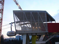


The Portland Aerial Tram is an aerial tramway in
The tram cost $57 million to build—a nearly fourfold increase over initial cost estimates, which was one of several sources of controversy concerning the project. A round-trip tram ticket costs $4; the tram is free for OHSU employees, patients, students, and visitors.
The tram consists of two stations and a single intermediate tower. Two tram cars operate on parallel track ropes and are pulled in unison by a haul rope which is driven by an engine at the lower terminal; when one car is at the upper terminal, the other is at the lower terminal, and vice versa. The lower station is located beside an OHSU facility in the South Waterfront neighbourhood, adjacent to a stop on the Portland Streetcar line, which connects the South Waterfront neighbourhood with downtown
The tram route crosses over Interstate 5 as well as major thoroughfares such as Barbur Boulevard, Oregon Route 10 (Naito Parkway), and Oregon Route 43 (Macadam Avenue). The intermediate tower is located east of Interstate 5 close to the South Waterfront station. As a result of this configuration, much of the journey is significantly elevated above the ground, making the tram easily visible for some distance, and providing tram riders with good views of the eastern metropolitan area and the Cascade Mountains of Oregon and
No comments:
Post a Comment